Showing posts with label St. John's NL. Show all posts

Monday, October 21, 2019

Next stop Ireland

If you were to sail northeast from Cape Spear, the first landmass you would encounter would be Ireland, hence the title. Remember to click the photos to see larger versions.


Cape Spear from the water.

Look up things to do in St. John's, and on most of the lists you'll find on the 'Net will tell you to go to Cape Spear and watch the sun come up. I can imagine that's great advice, and I actually thought about doing it. Unfortunately, we were often so tired that we slept until well after sunrise. I did manage to wake early enough one morning to catch a picture of the sun topping the mountains behind our hotel.

What's that you say? I could have set an alarm. Why, yes, I could have. But in the end, I'm glad I didn't. We used Google maps to find our way there, and the instructions were convoluted, to say the least. Even assuming Google was giving us the most direct and fastest route, you have to drive through the old part of town, where Google directs you to take what it generously calls roundabouts, which bear little resemblance to the roundabouts towns are so fond of trying to bring back in the states or to the ones we've encountered in other countries we've visited.

No, these roundabouts are more like the town squares you encounter in small, Texas (and I'm sure other states) towns where roads converge at the courthouse or a park built in the center of town and one-way roads ferry you to the road you need. Some of these St. John's roundabouts had been created by installing those large concrete barriers you see used in road construction to reroute traffic. The newer parts of town do have actual roundabouts, though.

You eventually arrive at the road that takes you to Cape Spear, which reminded me of the Kentucky backroads I drove on too many decades ago, going up and down, twisting one way then the next, often at posted speeds of 30 kph (about 19 mph) or less, signs Canadian drivers tended to ignore.

Given that I hate driving unfamiliar routes, driving in the dark, and driving twisty roads, the idea of combining all three so I could see a sunrise didn't appeal to me, and I was glad we'd skipped it. Later, a woman sitting in front of me on the plane was reviewing her trip photos, and she had some spectacular sunrise shots from Cape Spear. She also had some great shots of puffins along a shore, while we only saw the birds in flight. I was a bit jealous, but I got over it.
Marker proclaiming Cape Spear to be the easternmost point in North America.
A parking lot at the bottom of the hill where the lighthouses are provides two ways to begin your exploration. You do a lot of climbing, but the site provides lots of staircases so the climbs aren't overly taxing for most visitors. One path leads to the original lighthouse while the other leads to a lookout on the ocean with red benches to sit in to enjoy the view (at whatever time you visit) and a marker proclaiming this to be the easternmost site in North America, save Greenland.

This latter path is studded with signs warning visitors to stay away from the edges and be careful during dodgy weather because waves crashing against shore can come up high enough to sweep them to their doom. Cheery way to start a visit. I read later about a woman who'd ventured to close to the edge in June of that year, had fallen off and had to be rescued. That article mentioned that several people have died after falling.

Stairs lead to the "new" lighthouse. The sign in the lower left warns visitor's
of the risk of falling off the cliffside.

Anyway, as I mentioned in a previous post, Greenland belongs politically to Europe and most folks don't tend to think of it as part of North America. But geologically, the island is attached to the North American tectonic plate, making it technically part of the continent. But who wants to quibble with tourist marketing?

World War II bunker built into the hillside. From inside, a tunnel branches
off to the left leading to an exit near the stairs shown above.

We began at the lookout and started the climb to the newer lighthouse. Before we arrived there, we came upon a military installation from World War II.  Two large guns had been placed there to guard the entrance to St. John's, and a bunker providing ammunition storage and quarters for soldiers on duty had been built into the side of the hill..

Gun emplacement, without the lifting mechanism to raise the gun above
the concrete wall in front of the barrel.
A poster inside the bunker shows the gun with its lifting mechanism.

The guns were placed behind large, concrete structures that hid them from view. They were mounted  on risers that allowed them to rise about the concrete barriers and bear on traffic in the ocean. A circular track allowed them to be pointed wherever needed along the expanse from Signal Hill in the north all the way to the southern approached to the cape. The guns are displayed in place without the lift mechanisms. And yes, German U-boats had come close enough to the harbor to justify the gun placements

The original lighthouse. For some reason, I did not take pictures of the
interior where the lighthouse keepers and their families lived.

The entrance to the bunker from the guns leads to a hallway that exits on the side of the mountain, from which you can take stairs up to the second lighthouse, which was built to replace the original lighthouse. The original lighthouse served from 1836 to 1955, and its light, by then converted to an electric light,  was placed in the new lighthouse. I believe this second lighthouse does not still operate, but I don't know for sure.

You'll notice in the picture that the lighthouse is square. The government built a lighthouse and then surrounded it with the square part, which provided living quarters for a keeper and his family and workshop space. The building is set up using furniture and equipment from the mid-1800s, all very familiar to anyone who has visited museums featuring items from the period. Because the building surrounds the lighthouse, the interior walls are curved.

Other buildings on the site were being renovated, so I'm not sure what their purposes were.

More of the sights:

Looking back toward Signal Hill, which is the promontory to the left. You can
almost see Cabot Tower.
The clerk who checked us in at the hotel specifically mentioned the red chairs
at the cape as a good place to watch the sunrise.
Click this picture to see it bigger and you'll see numerous birds trailing after
these fishing boats. 
Sail northeast from the new lighthouse, and you'll arrive in Ireland.

Saturday, October 19, 2019

A whale of a time

The visits I'm about to describe actually took place on two different days.


Sailing, sailing

When we're on the seacoast as a result of a trip, we rarely skip a boat tour, the exception being when we are on cruises, which are really just extended boat tours. Normally we vacation in September, but for this trip I had read that whales and puffins usually leave by September, and I hoped we'd be able to see them before they departed.

So, on the Wednesday we were in St. John's, we made our way to harborside to hop on a boat for a tour. The operators don't bill the tour specifically as a whale watching tour, but hey, the actual harbor is pretty small so you can see most of it just by walking around on Harbour Drive. The crewman doing the PA instructions and historical description tells us to keep an eye out for spouts, which would indicate the presence of whales, and to sing out if we spotted any. Then we'd head that direction to find the whales.

I confess I didn't hear much of his spiel because I split time between the aft deck and the fore deck shooting pictures. So I can't relate the history. Talk to Sharon; she heard more of it than I did. After we cleared the harbor entrance -- better known as the narrows -- we headed out into the Atlantic for a bit, eventually turning toward Cape Spear, about which I'll say more in the next post. 

We hadn't been headed that direction long before someone saw spouts, and we turned toward them. While on the way, I had a short conversation with the crewman who made the announcements and admitted to him that we came to St. John's because of a TV show. He immediately knew what I was talking about and said he had also come there from Ontario because of the visuals on the show. He came to study at the marine institute, found the place as fetching as it was on the show, and stayed. 

Soon all the passengers began oohing and aahing and pointing to spouts. Then we began to see the creatures surface, though they didn't make any spectacular breaches like you get to see on the nature shows. 

When we drew near enough, the crewman identified our visitors as fin whales, the second largest of the whale species, growing to a length of about 70 feet and named for the single, large fin on their backs nearer the tail than the middle. 

Occasionally one would surface and go back down in a kind of long roll of its back, and you could easily see how long they were. The crewman told us to look for a change in the water color after we saw a spout, and that would indicate the whale's presence near the top of the water. Sure enough, the water would turn a light green, and then the beast would surface. I took video with my action camera, but it doesn't zoom well and has a wide angle lens, so the video I've linked to really doesn't show the whales as well as I'd like. But I carry the images around in my head of the closest encounter we've ever had with a whale. Too bad you can't shine a light in my ear and see my memory projected out the other ear.

Whales video (This is best viewed full screen, wide aspect on whatever device you're using. The most visible whale will be the last one.)

Caves along the shore just outside the harbor entrance. 

After watching the whales a while, we turned toward Cape Spear. As I said, I'll share more about this in the next post. After short time we headed back toward the harbor, passing a small village on the way, and made our way back to the pier.

Village outside the harbor not far from the caves above.  The crew guide 
said people would build villages pretty much any place where a cove 
provided a place where fishermen could pull their boats up on shore and 
be somewhat protected.

The Rooms

The Rooms, St. John's combination museum and archives building, dominates just about any clear view of the town's highest point. Built on the site of Fort Townshend, an 18th century British military fort that eventually fell into disuse and became buried, The Rooms house a multitude of exhibits covering art, culture, history, and natural history, and is home to the provincial archives. 

The Rooms

They call it The Rooms because its architecture mimics the simple, gable-roofed sheds, called "fishing roome" that once dominated the province's coastlines. 

We arrived there about lunchtime and did something we rarely do -- ate in the facility's cafe. That turned out to be a good call because the food was very good, and the view through the cafe windows overlooking the harbor was even better. 

Bumblebee lights like this one appear in various places inside the museum.


After lunch, we tackled the exhibits, or some of them anyway. We looked through an art installation in which the pieces were fashioned from items such as bone and baleen and other natural, mostly animal, materials. 

We checked out a section that discussed the influence of the Irish in Newfoundland history. Irish immigrants would come to the island to work in the fishing industry for several months of the year, then return to their country. Eventually many of them began to stay, bringing their families with them. According to the exhibit, at one time the Irish composed nearly two-thirds of the population. Even now almost half of the province's population has direct Irish ancestry. If you run into the right resident, you can hear the brogue in their speech (or you can watch the TV show I mentioned and hear it there).

In addition to the formal displays, kiosks and tables in the open spaces
provide interactive opportunities to visitors.

The other memorable -- to me -- exhibit detailed the first transatlantic airplane flight. London's Daily Mail held a competition for airmen to become the first to cross the Atlantic nonstop. In 1919 a couple of Brits, pilot John Alcock and navigator Arthur Brown, flew a Vickers bi-wing from St. John's to County Galway in Ireland in just under 17 hours. They encountered foul weather and mechanical difficulties, at times flying almost at sea level, to take the prize. 

The museum consists or four floors, and we spent time in a couple of other exhibits, but there's so much to see, and we spent several hours there without seeing it all. I told Sharon that it seemed to me that, if a person had time, he/she should spend three or four days there, taking one floor at a time, in order to see everything. 

Friday, October 18, 2019

We learn History of the World -- and Newfoundland -- Sorta

Going underground

With rain falling on Signal Hill, we decided to drive to the bottom of the hill and visit the Johnson Geo Centre, which promised to take us underneath the hill and give us an up close view of the geology associated with the site. 

You take an elevator down from the entrance and gift shop to the exhibition area. One wall of this section is composed of the rock that forms the substance of the hill, and shows how the hill formed primarily from uplift. Not exactly was I was thinking the center was about, but OK, it delivered on the promise.

Lecturers give informative programs at regular intervals, and we'd planned to attend one that started shortly after our arrival, but though we thought we had plenty of time, the timer above the entrance suddenly changed, and by the time we reached the doors, they had automatically closed. It's hard to describe how wonky that experience was, but we decided to just attend the next lecture. 

The one we attended featured a graduate student from the local university talking about the geology of the region and the role of glaciers in forming the landscape -- much of which we already knew, but we did pick up a couple of facts. Then he shifted to talking about icebergs, which regularly float past St. John's each spring. Some of the icebergs can be a problem for shipping in the area and have to be moved out of the way from time to time. They have developed a way to, in essence, put a giant lasso around these problem bergs and tow them out of the way with ships. The ice is dense enough that attempts to blow them up usually don't work well. 

Somehow we did not get a shot of the exterior of the Johnson Geo Centre.
This representation of the solar system greets visitors to the underground
portion of the museum. (Photo by Sharon.)


After the lecture, we toured some of the other exhibits. One hall was devoted to the Titanic disaster. It began with the cruise line's history, noting that Americans actually owned the White Star line at the time, and continued through until, well, you know how the story ends. Most of the information pointed out the various ways in which decisions to scrimp here or skip a step there led inexorably to the ship's end. 

Unlike the other exhibits we've seen, this one skipped the stories of the crew and passengers that made the other exhibits so compelling. Almost every descriptive sign ended with a section headed by a red banner emblazoned with "The Truth," which made sure you understood what a monumental foul up that particular part of the story represented. 

At the end of the exhibit, you can try your hand at a simulator that lets you take control of a submersible and drive around the ship's underwater remains. Either it wasn't working quite right, or I was monumentally incompetent at the controls, meaning I will never work for Robert Ballard. Or possibly a bit of both. I was unable to do more than approach the bow from the side and back up. 

This has nothing to do with the Geo Centre. It's in the visitor center across
and up the road a bit. The Newfoundland Chocolate Company has a small
cafe area, and Sharon took this shot of the mural in the dining area.

The largest exhibit area covers the history of the area from prehistoric times to the space age. We have begun looking at some areas adjacent to the rock wall when we noticed that a trail had been marked out on the floor using very large more-than symbols.

These lead you through the exhibit in a particular order -- though a lot of people ignored them. In general terms much of what was presented wasn't particularly new to us -- geological formations and how they come to be, migration of the first humans to the North American continent, types of rock, how various early settlers lived -- remarkably like those in other parts of the continent -- stuff we've seen at countless other museums. 

We spent a bit of time when the information was more specific to Canada or Newfoundland. By the way, I forgot to mention earlier that although Newfoundland became part of the British Empire a few centuries ago, it only joined Canada in 1949. Til then it was basically its own country.

By time we finished at the center, the rain had stopped, most of the day was gone, and we retired for the day 

Thursday, October 17, 2019

Lay of the Land

Remember: clicking any photo opens a larger version (or it's supposed to).

Walking around the old town

St. John's doesn't seem like a tourist city, but it is. Many of the folks we see in shops we drop into "come from away," a Newfoundlander expression meaning they came from somewhere besides Newfoundland, in case you hadn't already guessed. Of those whom the shop keepers ask, most say they come from somewhere else in Canada -- I hear a lot of them saying they came from Ontario, but I don't know that this means anything. 

By the way, if you were wondering, the name of the island is pronounced NEW-fun-land, with a short "a" in land and a slight secondary accent on the last syllable, not, as I usually say it, NEW-fun-lund. The name dates to Cabot's "discovery" of a new-found land. 

Anyway, tourism might drive a decent part of the economy, but as the provincial capital, St. John's hosts the province's Supreme Court, with a criminal section downtown, a more modern building housing the family division more centrally located in the city, and a large Canadian government building. A large university is also located in the city, along with an impressive looking medical complex.

Canadian government building. A shocking piece
of modern architecture that doesn't match the older
buildings in downtown.

The back side of the Supreme Court building. Despite its old appearance,
this building dates back to the early 1900s. The 
first building erected here dates
to the mid-1700s..

Downtown is also the old part of town, though not much remains that goes back more than a couple of centuries. Three "great fires" swept through the city in the 19th century, destroying large parts of the original township. 

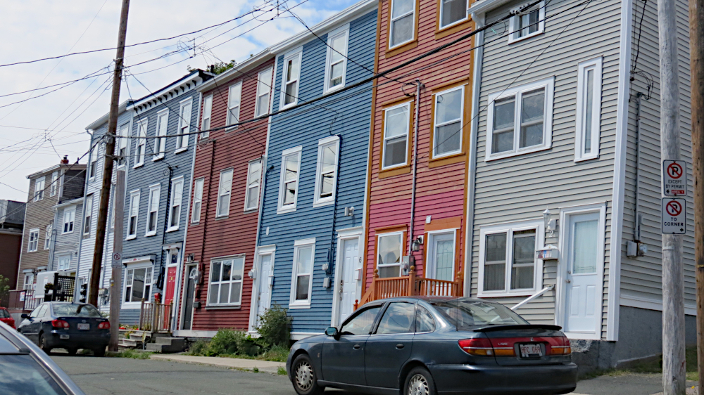
Three major streets run north-northeast to south-southwest, with one of them, Water Street, being the oldest street in St. John's. The other two streets are Harbourside, located along, well, you can guess from the name, and Duckworth, a charming street with many businesses in what used to be row houses -- and like the town's existing row houses, they are painted in bright colors.

Some of the jellybean houses downtown. These tend to be 
located on the cross streets to the main downtown streets. These
cross streets lead to the harbor and tend to be steep, almost as steep
as some San Francisco streets, though some 
of the sidewalks sport
stairs that make climbing a bit easier.

Look down the side streets in the old section of town, and you will see lots of row houses wearing these bright colors. The houses are often referred to as "jelly bean houses," and you can see other examples scattered about other sections of the city, some of which were built fairly recently. 

The origin stories about jelly bean houses vary according to who's telling them. The custom may go way back in city history and be the result of fishermen using the bright paints so they could pick out their houses as they sailed into the harbor, often shrouded in fog. Or as a tour guide told the bunch of us on a harbor cruises, the houses built after the Great Fire of 1892 were painted using boat paint because no one had any regular paint after the fire ravaged the city. Or, it was an initiative that sprung up as part of a revitalization effort in the 1970s. This last seems unlikely because historical records dating back to the first few years of the 1900s mention the gaily colored dwellings.  

Maybe if you combine all three, you have the real story. Or you can pick the one you like best. I like the first story because it sounds a bit like the story behind Dublin's painted doors -- only not involving drunken pub goers trying to find their way home. But the second seems plausible, and I can see a committee working on revitalization hearkening back to that time and encouraging owners to paint the buildings brightly as a way of recapturing a part of the city's heritage. 

The National War Memorial. The woman with the torch
represents 
Newfounland's willingness to serve the British empire.
The statue 
to the left is a sailor holding a spyglaas, while the one
to the right 
is a soldier in full battle gear. The figures in the middle
are a fisherman,
representing the Merchant Marine, and a lumberjack,
representing 
the Forestry Corps.

An imposing war memorial lies between Duckworth and Water streets. Unveiled in 1924, it originally commemorated Newfoundland's involvement in World War I. Since then, plaques have been added to mark the contributions of Newfoundlanders in World War II, The War of 1812-15, The Korean Conflict and Afghanistan. A park-like area leads from the cenotaph on Duckworth to Water Street. One website I looked at later said it is one of the most famous memorials in the world. Yeah, I never heard of it either, but it's still impressive.


Statues of a Labrador and a Newfoundland watch over
Harbourside Park. We ran into some people walking 
a Newfoundland downtown. It was a beautiful, and friendly,
black dog about 3/4 the size of this statue. The statue's head
came up above my waist.

Not far away lies Harbourside Park, a nice place by the water where you can lounge on one of benches and enjoy a pretty day. On Fridays during the summer lunchtime concerts are held, though we missed it because we were on our way back from the Viking site. A pair of statues representing a Labrador and a Newfounland dog allows the province the chance to crow about being the only place that can claim two dog breeds. Is that true? I dunno; that's what the sign said.

Some other sights about town:

St. John's Convention Center. It lies to the west of downtown so the architecture doesn't clash as much.
The left side of the 
building depicts icebergs that float down in the spring. Sometimes larger bergs have
to be towed out of the shipping lanes and 
harbor entrance.
This mural depicts the Great Fire of 1892. It was painted and dedicated in 2017.
A little better view of how steep the streets can be.
George Street, which is a bit like Bourbon Street in New Orleans. Restaurants and pubs,
along with open-air 
stage line the street, and live music can be heard at night, when
the street comes alive.
High temperature this day was supposed to be 80. Too hot for these guys.
Trapper John's Museum and Pub. The home of the screech-in. Although
many places have screech-ins, the ceremony seems to have originated here
as a tourist gimmick of the owner. Tourists can become honorary Newfoundlanders
by, among other  things, repeating some Newfie phrases, kissing a dead fish 
(on the mouth), and downing a shot of screech, which used to be a 
really poor quality rum drunk by sailors but is now a  regular distilled rum
with the brand name Screech. And no, we did not go through the ritual.