Thursday, October 17, 2019

Lay of the Land

Remember: clicking any photo opens a larger version (or it's supposed to).

Walking around the old town

St. John's doesn't seem like a tourist city, but it is. Many of the folks we see in shops we drop into "come from away," a Newfoundlander expression meaning they came from somewhere besides Newfoundland, in case you hadn't already guessed. Of those whom the shop keepers ask, most say they come from somewhere else in Canada -- I hear a lot of them saying they came from Ontario, but I don't know that this means anything. 

By the way, if you were wondering, the name of the island is pronounced NEW-fun-land, with a short "a" in land and a slight secondary accent on the last syllable, not, as I usually say it, NEW-fun-lund. The name dates to Cabot's "discovery" of a new-found land. 

Anyway, tourism might drive a decent part of the economy, but as the provincial capital, St. John's hosts the province's Supreme Court, with a criminal section downtown, a more modern building housing the family division more centrally located in the city, and a large Canadian government building. A large university is also located in the city, along with an impressive looking medical complex.

Canadian government building. A shocking piece
of modern architecture that doesn't match the older
buildings in downtown.

The back side of the Supreme Court building. Despite its old appearance,
this building dates back to the early 1900s. The 
first building erected here dates
to the mid-1700s..

Downtown is also the old part of town, though not much remains that goes back more than a couple of centuries. Three "great fires" swept through the city in the 19th century, destroying large parts of the original township. 

Three major streets run north-northeast to south-southwest, with one of them, Water Street, being the oldest street in St. John's. The other two streets are Harbourside, located along, well, you can guess from the name, and Duckworth, a charming street with many businesses in what used to be row houses -- and like the town's existing row houses, they are painted in bright colors.
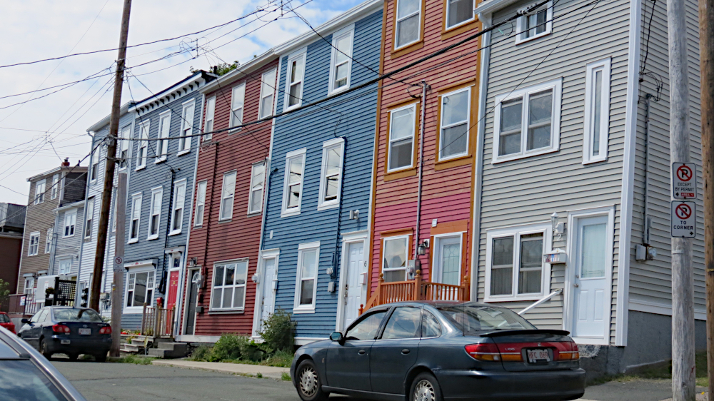
Some of the jellybean houses downtown. These tend to be 
located on the cross streets to the main downtown streets. These
cross streets lead to the harbor and tend to be steep, almost as steep
as some San Francisco streets, though some 
of the sidewalks sport
stairs that make climbing a bit easier.

Look down the side streets in the old section of town, and you will see lots of row houses wearing these bright colors. The houses are often referred to as "jelly bean houses," and you can see other examples scattered about other sections of the city, some of which were built fairly recently. 

The origin stories about jelly bean houses vary according to who's telling them. The custom may go way back in city history and be the result of fishermen using the bright paints so they could pick out their houses as they sailed into the harbor, often shrouded in fog. Or as a tour guide told the bunch of us on a harbor cruises, the houses built after the Great Fire of 1892 were painted using boat paint because no one had any regular paint after the fire ravaged the city. Or, it was an initiative that sprung up as part of a revitalization effort in the 1970s. This last seems unlikely because historical records dating back to the first few years of the 1900s mention the gaily colored dwellings.  

Maybe if you combine all three, you have the real story. Or you can pick the one you like best. I like the first story because it sounds a bit like the story behind Dublin's painted doors -- only not involving drunken pub goers trying to find their way home. But the second seems plausible, and I can see a committee working on revitalization hearkening back to that time and encouraging owners to paint the buildings brightly as a way of recapturing a part of the city's heritage. 

The National War Memorial. The woman with the torch
represents 
Newfounland's willingness to serve the British empire.
The statue 
to the left is a sailor holding a spyglaas, while the one
to the right 
is a soldier in full battle gear. The figures in the middle
are a fisherman,
representing the Merchant Marine, and a lumberjack,
representing 
the Forestry Corps.

An imposing war memorial lies between Duckworth and Water streets. Unveiled in 1924, it originally commemorated Newfoundland's involvement in World War I. Since then, plaques have been added to mark the contributions of Newfoundlanders in World War II, The War of 1812-15, The Korean Conflict and Afghanistan. A park-like area leads from the cenotaph on Duckworth to Water Street. One website I looked at later said it is one of the most famous memorials in the world. Yeah, I never heard of it either, but it's still impressive.


Statues of a Labrador and a Newfoundland watch over
Harbourside Park. We ran into some people walking 
a Newfoundland downtown. It was a beautiful, and friendly,
black dog about 3/4 the size of this statue. The statue's head
came up above my waist.

Not far away lies Harbourside Park, a nice place by the water where you can lounge on one of benches and enjoy a pretty day. On Fridays during the summer lunchtime concerts are held, though we missed it because we were on our way back from the Viking site. A pair of statues representing a Labrador and a Newfounland dog allows the province the chance to crow about being the only place that can claim two dog breeds. Is that true? I dunno; that's what the sign said.

Some other sights about town:

St. John's Convention Center. It lies to the west of downtown so the architecture doesn't clash as much.
The left side of the 
building depicts icebergs that float down in the spring. Sometimes larger bergs have
to be towed out of the shipping lanes and 
harbor entrance.
This mural depicts the Great Fire of 1892. It was painted and dedicated in 2017.
A little better view of how steep the streets can be.
George Street, which is a bit like Bourbon Street in New Orleans. Restaurants and pubs,
along with open-air 
stage line the street, and live music can be heard at night, when
the street comes alive.
High temperature this day was supposed to be 80. Too hot for these guys.
Trapper John's Museum and Pub. The home of the screech-in. Although
many places have screech-ins, the ceremony seems to have originated here
as a tourist gimmick of the owner. Tourists can become honorary Newfoundlanders
by, among other  things, repeating some Newfie phrases, kissing a dead fish 
(on the mouth), and downing a shot of screech, which used to be a 
really poor quality rum drunk by sailors but is now a  regular distilled rum
with the brand name Screech. And no, we did not go through the ritual.

Wednesday, October 16, 2019

Signal Hill

Remember: If you click on a photo, it should open in a larger size.

Every list of places to see in St. John's includes Signal Hill, and it appeared prominently in many, if not most, of the episodes of the TV show that drew us to the city.The entrance to the bay is flanked by two promontories. Signal Hill overlooks the north side of the opening. Built atop the hill is Cabot Tower, constructed to commemorate the 400th anniversary of John Cabot's discovery of the area and to mark the 60th year of Queen Victoria, who looks decidedly unlike Jenna Coleman.

The hill also formed a strategic part of St. John's defenses from the 17th century through World War. According to the official website, the final battle in North America of the Seven Years' War was fought here in 1762.

You can easily see the strategic importance of the area as you wander about the site. The entrance to the harbor is relatively narrow, and having gun emplacements overlook the harbor meant no ship attempting to enter the harbor could escape the reach of the long guns installed near the cliff edges. Look across the entrance to the other promontory, and you will see Fort Amherst, which I regret to say we did not visit.

One of multiple guns overlooking the harbor entrance. These guns fired
24 pound shot -- about the size of a cantaloupe.

Queen's Battery, built in 1796 and decommissioned in 1890. Most of this
is replica. The gun above is part of the array to the left.

Fort Amherst provided the harbor with another defense, first militarily, and later through the building of a lighthouse on the grounds. The lighthouse became the primary purpose for the fort and was staffed until 1982. The City of St. John's took over the property a little more than a decade later.

Fort Amherst

Cabot Tower served as a communications center for most of its active life before becoming a historical site. Ships arriving in the area would use signal flags to announce their presence, either directly or by signaling nearby Cape Spear, which would relay the information to Cabot Tower and from thence to St. John's.

Cabot Tower. The first floor is now a gift ship, and the second floor contains
interpretive exhibits. The second floor originally housed the wireless equipment
and operators. The top section provides access to the signal flags and
the lookout.

When wireless communication began, Cabot Tower became the hub for messaging between ships at sea and the city. Marconi received the first transatlantic wireless transmission at the tower in 1901, the letter "s," thus providing some of the earliest evidence that wireless signals could be bounced of the ionosphere and travel long distances.

Radio operators at the tower received transmissions in a variety of codes -- none of which I'd ever heard of before -- and converted the messages to Morse Code for sending into the town.

St. John's is the closest city to the spot where the Titanic sank, and signals from the doomed ship were received in Newfoundland some 85 miles south, so the area has a bit of a fascination with the Titanic story.

The forecast for the day we visited indicated that rain was possible late in the afternoon, so we went in the morning. Unfortunately Canadian forecasters have the same woes as their American counterparts. We had hiked a short distance down the hill to view a recreation of the hill's fortifications when a light mist started up. We made our way back to the top of the hill before the mist began to be driven by a freshening wind. Soon,the mist became a drizzle, all just before the firing of the noonday gun.

The noonday gun. Several guns have been used over the years. This one, a
3 pound Hotchkiss, once was part of the HMS Calypso, part of the Newfoundland
Naval Reserve. During the season, visitors to the site can fire the gun, after paying
$49C.

Ordinarily I would have taken photos or shot video of this ritual, but the weather was nasty enough that I did well just to stand behind the gun and listen to the re-enactor explain the purpose of the activity while sheltering my camera underneath my windbreaker. Oh, the purpose? The gun was fired in the beginning so ship's captains could set their chronometers, as keeping accurate time was necessary for determining longitude.

The gun was silenced three times in its history, the most famous interruption coming in 1906 because of complaints that the firing disrupted church services. That wouldn't have been a problem in any church I served because services had better have been over by that time. I mean really; members had restaurants to patronize and football games to watch.

Anyway, tradition won out over carping, but the incident sparked an idea for a clever song, the lyrics of which are remembered in a sign near the gun. You can read the lyrics here: Who Stopped the Gun? (If you know someone with an Irish accent or someone who can do a passable imitation, have him/her read the song to you. It sounds so much cooler.)

After the firing of the gun, we decide to head to the information center/cafe/gift shop to dry out and refuel for the next activity.

One of a small group, about a half dozen or so, bald eagles that decided
to grace our visit. You can't see it's head in this shot, the best I took, but
it wouldn't matter. This is a young eagle, and the head feathers don't turn
white until maturity. Until then, they're brown like the rest of the bird.

Tuesday, October 15, 2019

Go East, old people, go East

St. John's Harbor
Overlooking the St. John's Harbor. (Note: clicking any image will open
a larger version.)

Why Newfoundland?

St. John's, Newfoundland and Labrador, Canada, probably doesn't leap to mind when you're sitting around trying to think of a vacation destination. For that matter, when you hear Newfoundland or Labrador, you probably think about dog breeds before you think about a Canadian province.

I'd like to tell you that I wanted to go there because I have ties to Canada -- my maternal grandfather hailed from Stratford, Ontario -- and wanted to explore the history of the land, beginning with the nation's eastern province. But, I'd be fibbing. I never knew my grandfather and only knew anything about his being Canadian from comments my mother used to make and a little bit of genealogical research my sister once did. Mom and Dad did take a trip to Stratford once, but I can't remember a thing they told me about the place.

No, my reason for picking St. John's has to do with television, specifically a show called "Republic of Doyle," that streams on the Hulu video service. Allan Hawco, a Canadian actor from Newfoundland, plays a private detective who, along with his family and a perky blonde police detective, solves crimes in St. John's. Hawco is from St. John's.

According to IMDB, the series was filmed in St. John's, and the show often features gorgeous views of the city. This made me think it might be a great place to visit. After convincing Sharon that this insight might well be accurate, we set about making plans. I feared, however, from some of my early research, that we might not find enough to do, and while looking at a variety of Internet sites, I discovered that Newfoundland is home to the only verified Viking site in North America.

We'd been faithful watchers of the "Vikings" TV series and had read a couple of books on Viking history, so I figured we might as well include a visit to the site in our trip, which would take care of a couple of days worth of sightseeing time. I'll talk about that more in a few days.

St. John's bills itself as the site of the oldest port in North America as well as the easternmost spot on the continent. This is true if you don't include Greenland as part of the continent, which it is from a geophysical standpoint because it is attached to the North American tectonic plate, but as you may have learned from the news, Denmark runs Greenland, and the residents have proclaimed they are the owners. So take your pick.

 It is the capital of Newfoundland and Labrador, which is considered to be one province comprising the island of Newfoundland and Labrador, the mainland part of the province. St. John's is also the largest city in the province.

Looking toward the entrance to the harbor. 

John Cabot "discovered" the area in 1497 while exploring on behalf of England's King Henry VII. The Vikings, or Norsemen, had established a village on the western coast of Newfoundland about 500 years earlier, but the presence of native peoples or the lack of knowledge that other peoples might have been there first has never stopped exploring nations from claiming a discovery. Norsemen, by the way refers to seagoing traders and sometimes farmers from Scandinavia. When these traders and farmers took to conquering and warring, they were then called Vikings, at least according to our guide at the Viking archaeological site.

Cabot found the harbor and surrounding area on the feast day of St. John the Baptist and named the place after the famous saint. The island he called Newfoundland because it was a new-found land. Clever, no?

By 1500 a vibrant fishing industry was in place, and before the end of the 16th century an English fishing captain established a base in St. John's. A few years later one Sir Humphrey Gilbert claimed the area for Elizabeth I, marking the beginning of the British empire, according to sign in the harbor area. The first year-round residents, called "Planters" -- fishermen and their families -- established a presence in 1620.

At least one sign in the city refers to St. John's as the oldest city in North America, and it may well be for Canada, but other cities also claim the title. You can decide for yourself.

As you might guess from this brief history, fishing was for many years the lifeblood of St. John's -- cod fishing more specifically. Cod were so numerous that even though other species are now the main focus of the fishing industry, for some in Newfoundland, "fish" and "cod" are synonymous, with other species being referred to by their actual name. Unfortunately, the area became overfished, and in 1992 the government declared a cod moratorium. Licenses and fish plants have been severely restricted, and inducements to leave the fishing industry were offered. Still, fishing provides more than a billion dollars to the economy, and almost 18,000 people, about 3 percent of the island's population, are employed in the industry.

Some of the fishing (and other types of) boats in the harbor.

Culinary note: Fish rule on St. John's menus, even for breakfast. At supper our first night, a group seated at a nearby table asked if the cod were fresh or frozen. The waiter took umbrage and let them know that not only was the fish fresh, that restaurant served the best fish in the city. Subsequently he gave much of his attention to us, even making sure our order came out before the other table's.

One of the common offerings is "cod tongue." Because cod don't have tongues, you might wonder what they're referring to. Cod tongue is the bit of somewhat gelatinous meat from the cod's lower jaw. One article I read explained that the rest of the fish was too valuable to waste, so fishermen would collect this portion for themselves. It is fried and served with scrunchions -- diced, deep-fried pork fatback or salt pork. Didn't eat the cod tongue but did have scrunchions. Tastes a lot like the fatty portion of your bacon.


Friday, September 28, 2018

City by the Bay, part 5

Climb every mountain, or street in San Francisco


This will be our last full day in San Francisco. We want to walk the twisty section of Lombard Street, and the online travel guides I’ve seen suggest that you walk from the top down, where Lombard meets Hyde Street.. 

I check with Google, and because our hotel is just three blocks away,  at Lombard and Van Ness, the only route it will give me is a walking route. No bus route runs along Hyde, though a cable car does.. "Quit being a wimp" Maps seems to tell me. "Man up and walk it." 

From our hotel to the twisty part is all uphill. And I mean uphill, steeper than any hill we’ve climbed yet. I take my action cam with me to record the trek. When we watch the video later, we find it’s 16 minutes or so long, Take off the part where we wait at the light to cross the street and about a minute’s worth after our arrival, and we needed a good 12-13 minutes to walk those three blocks. The views from the top, by the way, are spectacular.


Top: View from the bottom at the intersection of Lombard and Van Ness
Middle: Two blocks up, looking back (we still have a block to go)
Bottom: Looking toward downtown from Hyde and Lombard (All photos
by Sharon O'Connor)

This part has been dubbed the world’s crookedest street -- although it isn’t -- and it was immortalized in the old movie Bullitt, with Steve McQueen. The trek down the hill is aided by a reasonably graded set of stairs. You could actually begin at the bottom and have a fairly easy climb to the top with those stairs.

Traffic was relatively light compared with what it’s supposed to be on weekends, and there was no shortage of Mustangs (McQueen’s vehicle in the movie). Lots of people crowded the bottom of the hill, all with cameras or cellphones taking pictures.

Our walk to Lombard and Hyde, sped up. Real time video here

Descent. Several cars recorded making the turns. (Regular speed)

A cable car route passes by a couple of blocks east of the bottom of the hill. We had planned to hop on it, but the route ends two blocks away from Lombard, about two blocks short of Fisherman’s Wharf, so we walked down. At the end of the line, the car is driven onto a turntable. A worker pushes a lever allowing the car to be sided onto a short stretch of track, and then one or more men manually push the car around to face the other way for its trip back into town

.Turning the cable car

After watching this process, we return to Jefferson Street, planning to pick up an electric street car to our next destination, a science-oriented attraction called the Exploratorium. I check with G Maps, which tells me we need to go back a block to a pickup spot. But looking at the map the hotel gave us, it appears we could just go to the nearest stop, steps away, on Jefferson and hop a streetcar there. It should circle the block and take us right by our destination. 

There are two streetcar lines, E and F. The streetcar that pull up at our nearest stop is an F-line car, and I ask the driver if we can get where we want to go by hopping on that car. He tells us no, but he’ll take us to a stop where we can catch an E-line car that will take us there. I take it from his answer and manner that we can only take the E line, but I’m confused because the lines share the same track.

We have to walk to another stop from where he drops us off, and by the time we arrive, the E-line car is leaving. And the next half dozen or so cars that come by are all F-line. So we walk back to the stop Maps had told us to go to, but we have to wait through three or four more F-line cars before an E. Arrgh. Bet if I hadn’t asked we’d have got there eventually.

Once an E-line car shows up, we hop on and head for our destination. The Exploratorium comprises several sections, some inside, some out. The main building is essentially a big warehouse with experiments for visitors to perform. Although this part is supposed to be split into six themed sections, you only know when you pass from one to the other if you see the section number on the wall.

Unlike most museum exhibits, there is no flow, no set of signs that lead you from one demonstration to the next. Instead the experiments are scattered about on the floor, and you wander from one to the other. Some were interesting, others less so. One of the ones we like is the Slinky escalator. You start the Slinky doing it’s thing on a tilted, motorized belt, then adjust the speed of the ramp to keep the toy flip-flopping along. I can’t set the speed to keep the toy going in place, so it tends to creep up the ramp, causing me to slow it down and make the toy start walking down the ramp.

Playing with the Slinky escalator

I eventually tired of the whole thing, needing more structure, more learning instruction. Sharon was receptive to leaving, so we walked to the Ferry Building Marketplace, a huge historical building that used to be the focal spot for visitors arriving in or leaving San Francisco by ferry.

With the rise of automobiles and the creation of the two main bridges, the building lost its importance. But it was rescued to become a shopping area and a mecca for the artisan food community. We ate lunch at a fish market -- very good -- and wandered about for a while, stopping at a place that made cheesecakes, including packages with three bite-sized cakes that we indulged in. Yum. 


Top: The Ferry Building Market. A popular place to be

Bottom: Bicycle rickshaws are all over the touristy parts of Embarcadero
Street and the wharf areas, which are fairly flat. And they constantly solicit
pedestrians

We grab another streetcar -- F-line back to Fisherman’s Wharf -- with no trouble at all. When we arrive at the appropriate stop, Sharon rushes off the car and begins looking frantically around.

“We have to get to the water,” she says, fretting because she can’t see a way there. I want to know why, and she finally explains she had seen a number of sailboats with identical sails. I note that we are near the area where we’d boarded the tour boat a couple of days earlier, so we’re near Pier 39 and the sea lions. 

We scurry down to the end of the pier -- the seals were being quiet at the time -- and join a crowd of people who’ve gathered for the same purpose we’re there. A fleet of one-design boats are sailing around Alcatraz Island. We’re not sure if this is a race or what, but I quickly count 25 boats immediately visible. We know more are out of sight, so I guess 30-40 boats minimum are involved. It’s an impressive sight.

Sailboats and pelicans


From here we go have a soda, then catch a bus back to the hotel -- we’re just not up to anymore walks up hills this day. But our day isn’t over.

Sharon’s been wanting to be at bayside to take some sunset photos. So after resting up a bit, I ask if she still wants to go. I can be really dense. But I’m thinking that sunset will be the same time it is at home. It isn’t; it’s 10 minutes earlier. By the time we arrive bayside, the sun’s already down -- and has been awhile. Still, it’s twilight, and with the proper camera settings, we should be able to snag some interesting pictures. 

So we take some shots -- Sharon gets talked into taking pictures of a young woman who was struggling to take the selfie she wanted -- gaze at the scenes, and head back to the bus stop, where we have the same driver who’d dropped us off. He remarks that we didn’t spend much time in the area. He’s right, I’m sure, but it seemed like a fairly long time to me.

By the time we're back at the hotel, we agree we've had a good day, and though we haven't exhausted the sight-seeing opportunities, we've had a good visit and are ready to go home.

Wednesday, September 26, 2018

City by the Bay, part 4

Geeking out and misusing technology


We start the day a bit later than we did the one before, which coincidentally, started later than the one before it. May be a pattern forming. Also, as I dress, I find that my clothes fit more loosely. Hmm.

The plan today is to head to Golden Gate Park and go to the California Academy of Sciences. If we have time left, we may wander about some of the park. The first part of the plan will work out.

Interior of the California Academy of Sciences. I don't have
an exterior shot, 
Why not? I'm really sure, so the simple answer
is because neither of us took one.

The reason the second part doesn’t work out is because this is a fascinating place for science lovers. It combines a rainforest, an aquarium, a planetarium, natural history and a living rooftop, among other things. The rainforest was closed, but we still had plenty to explore.

A planetarium show was included in the admission, and we had a few minutes before the show started, so we wandered around a bit looking at some of the exhibits.

T-Rex skeleton near the entrance. (Photo by Sharon O'Connor)

Pretty sure this is a whale skeleton

A number of student groups had invaded the academy, and several organizations had set up displays, mostly climate and ecology centered, and pretty much geared toward the students. We picked up a free, LED light bulb at one of the displays while wandering around. Strangely, I seemed to know more about the relative virtues of incandescents versus fluorescents and LEDs. than the woman manning the booth.

Most of the exhibits are interactive in a variety of ways. One exhibit that fascinated me contained heavy, colored nylon strings, about the size of standing bass strings, in front of LCD displays. Each of the four strings was a different color and tuning, and plucking a string would cause the display to show a fact about that display’s topic. Each factoid remained on screen as the next string was plucked. If you strummed all four at once, all the information would display in rapid succession.

The planetarium show took us on a tour of the universe, with an emphasis on star formation. Interesting, immersive film, but not much new info for a former science teacher and her husband. When the show ended, it was time for lunch.

We actually ate lunch in the museum cafe, and like most of the meals we had, our food was locally sourced, organic, etc. It was also good, though I suppose it can be hard to mess up a pulled pork sandwich. A woman sitting behind Sharon with her baby provided me with a lot of entertainment while we ate.

We went to the aquarium after lunch, and though it covered much of the same territory as the Aquarium of the Bay, I enjoyed it more for some reason. Somehow the layout and presentation of information captured my interest better. No tunnels though.

In the reef section

An alligator snapping turtle. This guy was huge. The shells on these
animals can reach almot 3 feet. This specimen was every bit of that.

At a tidal pool display you were allowed to touch the animals -- gently, with one finger -- and like many aquariums they had a pool with skates and rays you could interact with. A couple of the rays would turn sideways along the rock edges and flap their fins against the rock. Not sure what that was about.

Looking at one of the exhibits, and a guest drops in.

We went to the “living roof”, which contains a number of features designed to reduce energy use and provide some illumination and energy to help run the academy. All kinds of plants grow on the roof, and excess rainfall is channeled away from the roof for later use. We finished with the mineral and gem exhibit.

The living roof. It covers 2.5 acres. The sign says the idea was to capture
the concept of picking up the ground and putting a museum underneath. (Photo
by Sharon O'Connor) Scroll to the bottom for more random pictures.

We’d eaten up most of the day and decided to return to the hotel, so I pulled up the bus route. GPS is one of mankind’s great inventions, but like any tool, it’s only as good as the person using it. I misread the map -- mostly because I assumed we need to go back the way we came, and led us out the wrong side of the park -- in the opposite direction of where we should have gone, in fact.  Sharon pulled out the map the hotel folks had given us and figured out why we weren’t finding the bus stop and then used it to figure out the best route to take. Once that was accomplished we grabbed an appropriate bus and headed back.

The route took us through Haight-Ashbury, the hippie haunt of the ‘60s, and past Glide Memorial United Methodist Church, which was a flashpoint of the ‘70s in United Methodism with its support of the gay community and other liberal causes, but we only viewed them through the bus window. Our stop was less than a block from the hotel, so no steep climbs today.

Still, we tried to watch some streaming TV -- the WiFi was that good -- but I kept falling asleep during the shows and waking up for the endings. The night before, we’d tried to watch a movie I’d downloaded, and I nodded off frequently through that as well. I’ve gone back and watched some of what I missed, and everything made so much more sense. Go figure.

Only one day left. Right now it doesn’t feel like enough.

Parts of the park near the academy the we didn't get to see. Above,
the Music Concourse. Below, the deYoung museum, a fine arts museum.


Penguins, because who doesn't like penguins?

Tuesday, September 25, 2018

City by the Bay 3

We didn't leave our hearts, but they have plenty around town


On Tuesday we activate our three-day bus pass, which will last us for the rest of our stay. Once upon a time in Abilene I used the city bus system because we only had one car, and Sharon sometimes needed it. That experience did not exactly prepare me for using the Muni.

For one, Google maps didn’t exist. Now, you tell Google where you want to go, tap the bus icon, and you receive precise directions on which bus or buses to take, when the bus will arrive, how long your trip will be and where to get off.

For another, multiple buses run the routes -- at least the more traveled ones -- and you rarely have to wait long until a bus comes along. Also, you can only get off the bus at designated stops -- Abilene buses would let you off at the next block after you signal for a stop -- but the stops were always pretty close to our final destination. 

Today we’re going to the Golden Gate Bridge, and we make it our first stop because we want to walk for a while on the bridge. Another small craft warning is in effect for the afternoon, which means the walk will likely be more pleasant in the morning.

One suggested activity is to rent a bike, cross the bridge to Sausalito, and take the ferry back. My eye doctor told me that would take a significant part of the day, and we want to see some other sights.

Iconic view of the Golden Gate Bridge with a redhead walking by. Colors
aren't quite a match. Statue to the left is the bridge designer.

The plan is to walk to the middle of the bridge -- not quite a mile -- and come back. Bikes and pedestrians share the same area, with a lane for each. The two lanes are about the width of a car lane, with occasional spots a bit wider. And it’s two way traffic, which creates a need to be aware of your surroundings as more people show up and crowd onto the bridge.

The view from the bridge is spectacular. Several turnouts appear along the way, and I could hang out at one of those for hours, watching the boats and ships go by. At one point Sharon notices that a ledge below us is nearly covered with change. Whether tourists are throwing coins down there or losing money some other way isn’t clear. But the same area has caught numerous ballcaps, no doubt blown from their former owners’ heads.

Bridge tower from the walking/biking path
Some of the multitudes of crafts we see entering the bay. I looked
the weird orange things up -- they're Sail Drones, self sailing craft
used for oceanographic research. Given that they're supposed to be able
to sail themselves anywhere, I'm not sure why these were being towed.
Maybe just a faster way to bring them in because they only sail at 3-5 knots.

Further across, Sharon thinks she sees a small pack of dolphins in the water below. I manage to get a picture, and when we look at it later, the critters look more like seals or sea lions. After blowing it up on the computer for a better look, I’m leaning toward seals.

What do you think? Seals? Otters? Something else?

While walking back to the visitor center, we see a bridge patrol car move in front of the northbound traffic and begin weaving across the lanes causing quite a backup. I meant to ask why they would have done that but must have been distracted by a shiny object -- or maybe the giant brownie I bought at the cafe for a snack. At any rate, the question went unanswered, along with one about the money..

Another area our hotel hosts suggested we visit was Union Square, so we figure out the buses to take and head that way. We plan to grab lunch, check out the shopping and grab a cable car back to the bay.

The actual square is an island in a sea of tall buildings. One corner seems occupied by the hop-on/off bus companies, whose sales reps are kind of annoying. but the rest of the area contains a couple of cafes, lots of places to sit and relax, some interesting plants and a couple of Hearts of San Francisco painted heart sculptures -- a series of them scattered around town. Seems like a popular thing to do. I’ve seen painted cows, dolphins and a couple of other things I can’t think of now. Tony Bennett painted one of the hearts displayed at Union Square.

Union Square
Tony Bennett's heart

Two things stand out about the square. First is the giant Nike ad that overlooks the northeast corner -- the infamous Colin Kapernick ad. Don’t know if the company thought it would be well received there or if it was trying to tick people off.

Please, no comments. This is not an endorsement, just an illustration

The other was how quiet it was once you moved away from the bus people. This despite the number of people, and the amount of traffic. It was weird, but I guess the surroundings or the plant life or something soaks up the sound.

We find a restaurant nearby that offers American comfort food with a modern twist -- according to its own description. Sharon orders a wrap, and I pick one of their specialties, chicken pot pie. I order the small one and am glad I did when the server brings it because it’s pretty big. And to my taste buds, it is delicious. A light, flaky, almost croissant-like crust with a filling to die for.

Lots of stores and attractions are located in the blocks surrounding the square proper, but now we’re here we decide to skip the shopping and head for the cable car stop. The car is nearly full, but there’s room inside, not ideal for viewing, but the operator is a riot.

The cable car we rode. We want to go again and ride on the outside
but somehow never managed to pull that off. (Photo by Sharon O'Connor)

The view from our cable-car stop. Hills? What hills? (Photo by Sharon
O'Connor)
Just as we begin the trip, he begins yelling at a woman on the outside of the car, saying he was near-sighted and had forgotten his glasses. Could she read a sign for him? She didn’t seem to react so he tried again. Again, she didn’t respond, so he says, “The sign says don’t lean out of the car!”

A bit further on he starts shouting at someone on the street who wants to board. “No drinks! No drinks!” When the man hops on, the driver says, “Man, you dirtied up our city.” The man ignores the driver. I don’t know what the passenger did -- maybe tried to ditch his drink in a trash can, missed, and didn’t bother to pick it up before boarding?

Still a bit further on the driver spots a man selling nectarines from the trunk of his car, which is parked at a corner we have to stop at. He yells out that he wants a nectarine and asks the passengers on that side of the car to relay the message to the vendor. Someone finally does, and the nectarine is duly passed to the driver. He offers to pay the vendor, but the offer is rejected. He tells the vendor he’ll see him again the next day, if he’s there.

At still another point in the trip, he lets the car go flying down a hill and shoot up the next like a roller coaster, then breaks into a laugh and points to one of the passengers saying, “This lady had a tan when she got on today.” He is inordinately pleased with this joke and starts teasing the woman directly.

Operating the car requires a full-body effort on his part, both arms and leg come into play as he rings the car’s bell, pulls and pushes its levers, and stands on a big pedal that seems to be part of the braking system. Fun to watch.

We reach the end of the line and head back down to the piers. Pretty much each day will end down here. We love watching the activity on the water.

Another daily routine involves stopping in at McDonald’s to take a load off and drink a cheap soda. This one has a couple of the do-it-yourself, touch-screen ordering kiosks, which are apparently not widely available overseas. Many of the foreign tourists watch customers operate the kiosks with a kind of fascination, chattering and pointing at the device, and then opt to order at the counter.

We walk down to Hyde Pier, which is part of the National Park’s national historical maritime area. Several historic ships are anchored there, which you have to pay to view up close, but the park also offers several free exhibits. One involves a man working on restoring a wooden boat using traditional techniques. Today he is ramming caulk between the planks that make up the boat’s hull. Tedious for him but interesting for us to watch.

Hyde Pier, part of the Maritime National Historical Park. The boat
behind 
the sign is the Eureka, a steam-powered, side paddle-wheel ferry
built in 1890
After viewing the free exhibits, we decide to walk back to the hotel again. Those hills seem steeper, but we know we can climb them, so they are also a bit less intimidating.  This night’s sleep will be a good one.

Monday, September 24, 2018

City by the Bay 2

That big, red thing is kinda famous, according to the recording


We plan to take a sightseeing tour of San Francisco Bay and then visit Aquarium of the Bay. Online advice suggests taking the tour either early in the day or later in the afternoon to avoid crowds. Both are located near Fishersman’s Wharf, several blocks east of Ghirardelli Square. Our bus passes are good for three days, so we’re saving them for our last three days in town.

Let me say that although we take our vacations in September or October to avoid big, tourist crowds, apparently this part of September (second week) is still full-on tourist season. And it’s not just older people who have no children in school. Our fellow tourists are all ages and seem to come from everywhere. Our hotel sounds like a veritable United Nations at breakfast, and the same is true when walking the streets. We chat with a Slovenian couple, a family from Yorkshire, England, an Aussie couple and a few other folks with accents I can't identify and fail to ask about.

I check the weather forecast and see that there’s a small-craft warning for early afternoon continuing through 9 p.m., meaning the winds will be sort of high, so we decide to take the first tour of the morning. We arrive early and stroll the pier, taking more pictures and listening to the crowd of sea lions that have taken up position at the end of the pier across the water. Between them and the seagulls, the noise level is pretty high. Lots of people fish from the pier, but I don’t see anyone actually catching anything.

Fishin' and visitin' on a beautiful day/


Sea lions at Pier 39.

We board at the appointed time, joining what is indeed a smallish crowd. We take up position near the bow, pretty much by ourselves, but once underway quite a few folks come join us, pushing to the front for the best positions. Still, there aren’t too many passengers to prevent us from being able to move side to side and have decent views of everything being pointed out on the PA.

At one point on the way out toward the Golden Gate bridge, we’re joined by some dolphins, but they don’t stick with the boat and race on ahead. The tour narration makes quite a point about the uniqueness of the bridge and the various complications involved in building it. It is indeed a sight to behold, and like most famous, iconic places, is more impressive in person than in all the pretty pictures you’ve seen.

The narration went on an on about this bridge, like it was specialor something.

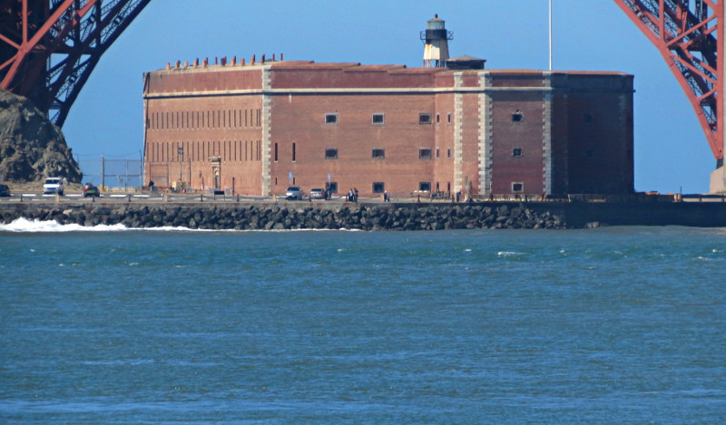
Fort Point, built during the Gold Rush era. It was slated for demolition 
when the bridge was being built, but the bridge designer wanted to save it 
and included a framing arch in the bridge design to save the fort.

We’ll go past Alcatraz on the way out and the way back, coming closer on the way back. (No, we didn’t take a tour of Alcatraz. Why? Because we didn’t. Same is true for any other attraction you don’t see mentioned later. We were tourists, but we didn’t try to see or experience everything, so some popular sites weren’t visited.)

Gentlemen, welcome to the Rock.

I believe that about covers it.

I can’t tell you much about most of the narration because I didn’t listen closely. I was there to take pics and soak in the sights, meaning I missed a lot of (probably cool) history. We didn’t see fog on this trip, but a haze seemed to hang over the city and bay most of the time, lessening visibility unless you were close. We sailed to the other end to see the Bay Bridge then headed back to the dock. By the time we returned most of the gulls had left, and most of the sea lions were asleep. 

See what I mean about the haze?

It was close to lunchtime by the time we returned, and Pier 39 was close by, so we decided to try a seafood place there. Several options were available, and we elected to go to the nearest one, Fog Harbor Fish House. Turned out to be a rather swanky place, where the food on the lunch menu cost nearly twice what we would ordinarily pay for a meal. But hey, we were on vacation, and everything seems expensive in San Francisco, at least in the touristy parts of town we frequented. Sharon had some sort of fish, and I had a shrimp dish that was so loaded with minced garlic that my mouth tingled by the end of the meal. It’s a wonder Sharon hung around me for the rest of the day. Days later I think I’m still exuding garlic, but that might be my imagination.

I found the Aquarium of the Bay to be vaguely disappointing in ways I can’t really express. But it was a cool enough place, especially a glass tunnel area on the lowest level that mimics the bay environment near the docks.

Hard to tell from this pic, but these jellyfish are huge.


We saw sharks and rays and all manner of fish. At one point I was quite surprised to turn and see a monster fish floating near the tunnel wall, staring at me at eye level. That guy was as big as me.Here's a vid of him swimming past a bit later.


The other display I really enjoyed was the river otters. The pair in the tank were quite lively and entertaining. One of them quite enjoyed doing back flips in the water.

Because we were right at Pier 39, we decided to check out the rest of its offerings. Pier 39 is a quintessential tourist area, and the travel guides often tell you to skip the concourse for that reason. The masses clearly ignore the advice. We spent quite a bit of time browsing the shops before deciding to head back to the hotel.

At this point, we are much farther away than the seven blocks it takes to arrive at Ghirardelli Square, but we plodded on, stopping occasionally at souvenir shops along the way.. The hills seemed a bit steeper this time, but we managed anyway. Sleep came easily this night.